Customized Solutions for Every Industry.


worldwide clients


At Ailena, we combine innovation and expertise to deliver cutting-edge solutions tailored to your needs. We’re your trusted partner in driving business success.
Customized Solutions for Every Industry.
Expert Team with Proven Success.
Innovation Meets Excellence at Ailena.
Discover how our diverse services unlock your business’s potential. From AI and software development to cybersecurity and predictive analytics, we provide solutions tailored to your needs
AI Consulting :- Transform your operations with expert AI guidance, from strategy development to implementation, ensuring you harness AI's full potential for business growth.
AI Product Development :- Create innovative AI-driven products designed to solve specific problems and enhance user experiences, tailored to your industry needs and goals.
AI Software Development :- Develop custom AI software that integrates seamlessly with your existing systems, optimizing performance and driving efficiency with cutting-edge technology.
Data Science Services :- Leverage data science to extract actionable insights from your data, helping you make informed decisions and drive strategic growth.
ML Consulting :- Implement advanced machine learning models to improve accuracy and efficiency, tailored to your business challenges and objectives.
Generative AI Consulting :- Explore the potential of generative AI to revolutionize your industry, with expert advice on leveraging AI for creative and practical applications.
AI Chatbot Development :- Enhance customer interaction with intelligent chatbots designed to provide seamless, automated responses and improve user engagement across platforms.
LLM (Large Language Model) Development :- Utilize advanced language models for sophisticated text generation and analysis, improving communication and content creation processes.
Recommendation Systems :- Implement personalized recommendation systems to boost user engagement and drive conversions by suggesting relevant products and services based on user behavior.
Data Capture by OCR :- Automate data extraction from documents using Optical Character Recognition, improving accuracy and efficiency in processing and analyzing text-based data.
Image Recognition :- Apply advanced image recognition technology to identify and analyze visual data, enhancing capabilities in areas like security, quality control, and customer insights.
Web Development :- Build responsive, high-performance websites that captivate your audience and enhance your online presence, tailored to your business goals and user needs.
Mobile Application Development :- Design and develop mobile applications that offer engaging user experiences and functionality, ensuring your brand reaches users on any device.
eCommerce Applications :- Create robust eCommerce solutions that drive sales and streamline online transactions, equipped with features to support a seamless shopping experience.
NFT Development & Marketplace Solutions :- Custom NFT smart contracts NFT marketplace development NFT minting platforms Digital asset tokenization Integration with Ethereum, Polygon, BNB Chain.
ICO / IDO / STO Launch Services :- Whitepaper drafting & token economics Smart contract creation (ERC-20, BEP-20) Token pre-sale & public sale setup ICO dashboard development Exchange listing support.
Crypto Exchange Development :- Centralized (CEX) & Decentralized (DEX) exchanges Multi-coin wallet integration KYC/AML module Liquidity management Order matching engine Admin & trader dashboards.
Smart Contract Development :- Secure smart contract coding Auditing & vulnerability assessment Automation of business workflows
Blockchain Consulting & Architecture Design :- End-to-end blockchain strategy Use-case identification Enterprise blockchain adoption roadmap
Web3 Development :- dApp (Decentralized App) development Web3 wallet integration Web3 login & authentication DAO platforms
Token Development :- Utility tokens Governance tokens Security tokens Multi-chain deployment.
DeFi (Decentralized Finance) Solutions :- Staking & yield farming platforms Liquidity pools Lending & borrowing protocols Automated Market Makers (AMM)
Blockchain Infrastructure Services :- Private blockchain setup (Hyperledger, Quorum) Node deployment & maintenance Blockchain API development
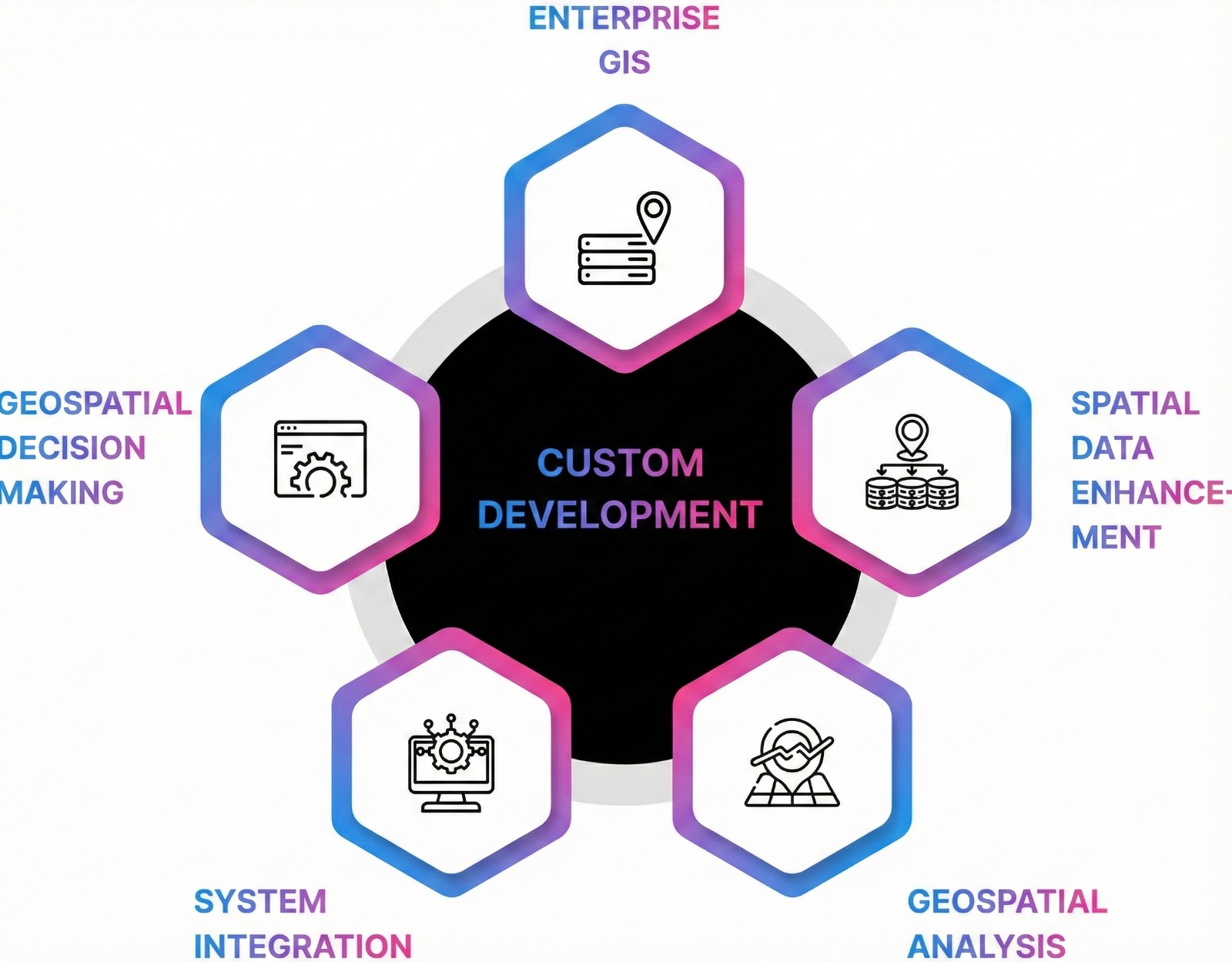
Ailena Technologies provides enterprise-grade Geospatial (GIS) services that help organisations transform complex spatial data into clear operational insight. We design, support, and deploy GIS platforms that strengthen decision-making, streamline field operations, and improve spatial awareness across sectors.
Core Capabilities :
Geospatial Applications :- High-performance web maps, dashboards, and spatial interfaces.
Spatial Data Engineering :- Satellite, drone, LiDAR, IoT, and survey data processing with automated QA/QC.
Spatial Analytics :- Geoprocessing, raster/vector analysis, terrain evaluation, and predictive modelling.
Location Intelligence :- Routing, network modelling, risk scoring, and operational simulations.
Enterprise GIS Systems :- PostGIS optimisation, ArcGIS/QGIS integration, and GeoServer/Mapbox deployments.
Remote Sensing :- Imagery processing, classification, and feature extraction.
A dedicated GIS delivery and QA unit ensures all solutions meet strict accuracy, reliability, and performance standards.
Neuroimaging Data Analysis :- Analyze complex neuroimaging data to gain insights into brain function and disorders, supporting research and clinical applications with advanced data analysis techniques.
Cognitive Computing Solutions :- Develop cognitive computing systems that mimic human thought processes, improving decision-making and problem-solving capabilities in various applications.
Network Security :- Protect your network infrastructure from threats with comprehensive security measures, ensuring data integrity and minimizing risks to your business operations.
Data Protection and Encryption :- Safeguard sensitive information with robust encryption and protection strategies, ensuring compliance with regulations and securing your data from unauthorized access.
Secure Application Development :- Build applications with security as a priority, incorporating best practices to prevent vulnerabilities and protect against potential cyber threats.
Risk Assessment and Management :- Identify and mitigate potential security risks with advanced risk management strategies, enhancing your organization’s resilience against cyber threats.
Compliance and Regulatory Consulting :- Navigate complex cybersecurity regulations with expert consulting services, ensuring your business meets all compliance requirements and industry standards.
BIM Services :- We deliver next-generation, AI-powered Building Information Modeling (BIM) solutions that are revolutionizing how construction and infrastructure projects are planned, executed, and managed. By integrating intelligent 3D/4D/5D modeling, AI-driven clash detection, and predictive project analytics, our solutions help reduce construction risks, lower costs by up to 30%, and accelerate delivery timelines. Leveraging generative AI for real-time design automation and fortified with enterprise-grade cybersecurity, we ensure your digital assets remain secure from design to operation. Whether it's smart facility management through IoT-enabled digital twins or city-wide planning with GIS-integrated platforms, Ailena’s BIM innovations are built to scale across industries. From healthcare and manufacturing to smart cities and large-scale infrastructure, our clients trust us to deliver faster, smarter, and more resilient outcomes.
IoT-enabled :- IoT-enabled digital twins for smart facility management to GIS-integrated BIM platforms for urban infrastructure, Ailena’s BIM innovations are built to scale. Industries such as healthcare, manufacturing, smart cities, and large-scale infrastructure rely on our solutions for enhanced operational insight, streamlined collaboration, and resilient outcomes. Our clients trust us to deliver BIM experiences that are faster, smarter, and future-ready.
Years of Experience
Leveraging over 4 years of industry expertise for optimal solutions.
IT Problems Solved
Successfully resolving 6800 IT issues with precision and efficiency.
Satisfied Clients
Serving 6960 clients with exceptional satisfaction and tailored solutions.
Pro Team Members
Our team of 39+ professionals delivers expert, innovative services.
Partnering with innovative companies worldwide
India Partnerships & Accreditations

Choose us for unmatched expertise, personalized solutions, and a dedicated team committed to driving your business success and innovation.
Proven track record in delivering solutions.
Cutting-edge technology tailored to your needs.
Dedicated to exceeding client expectations consistently.
All-encompassing offerings for diverse requirements.

We partnered with Ailena Technologies for a complex software development project, and they delivered beyond our expectations. Their team's expertise and professionalism made the collaboration seamless and successful.
CEO of Tech Innovators Inc
Ailena Technologies provided us with cutting-edge AI solutions that transformed our operations. Their innovative approach and commitment to excellence are unmatched.
Product Manager at ChatGuru
Working with Ailena Technologies was a game-changer for our business. Their custom web development services brought our vision to life, and the results speak for themselves.
CTO of Digital Dynamics
Ailena Technologies' expertise in predictive analytics gave us a significant competitive advantage. Their insights helped us make data-driven decisions that led to measurable growth.
Head of Marketing at RetailNext
The neurotechnology solutions provided by Ailena Technologies were instrumental in advancing our research. Their tools and support were invaluable.
Research Lead at NeuroLab
Ailena Technologies' cybersecurity services ensured our business remained secure in a challenging digital landscape. Their proactive approach to security was exactly what we needed.
IT Director at SecureNet Solutions